About the Abrams Falls Trail
The Abrams Falls trail in Cades Cove is one of the most well-known waterfall hikes in the Smoky Mountains. The hike is moderate in difficulty and is a short 5 miles round trip. For beginner hikers, this trail is perfect! When you’re hiking Abrams Falls in Cades Cove, you should plan on spending about 3 hours of your day in the mountains (or a little longer if you plan to spend extra time admiring the waterfall).
The trail is a little rocky and dirt-packed, so you’ll want to be sure to wear comfortable hiking shoes. This hike is alright for families, but if you have very small children, you may want to consider a shorter, nature trail since the trail may be too difficult for young children.
Abrams Falls Directions
From Gatlinburg, turn right at the Sugarlands Visitor Center onto Little River Road toward Cades Cove, where you will travel nearly halfway around the 11-mile loop road to the parking area for the 5-mile round-trip hike to Abrams Falls. From Townsend, you should take TN 321 to the national park entrance, turn right on Little River Road and head toward Cades Cove.
To reach the Abrams Falls trailhead, you’ll need to drive along the one-way Cades Cove Loop Road approximately 5 miles, and turn right onto a gravel road that ends within 0.5 mile at a parking area. Signs mark the area well, but you should know you’ve gone too far if you get to the Cades Cove Visitors Center. The Abrams Falls trail begins at the wooden bridge at the end of the parking area.
Since the departure point for this hike is in Cades Cove, you will find little solitude unless you are hiking very early in the morning or during the off season (before May or after the last pockets of fall color have disappeared.) To estimate whether or not the Cades Cove hiking trail will be busy, take a look at the parking area. If you are forced to park away from the designated parking area, the trail will most likely be busy.
Elevation of the Abrams Falls Trail
You will climb to approximately 1,800 feet at one point, but when you arrive at the waterfall, you will actually be 300 feet lower than your starting point.
About Abrams Creek and Abrams Falls
From the parking area, enter the forest and cross the wooden bridge at Abrams Creek. The trail leads right 0.5 mile to the Elijah Oliver Place and left to begin the hike to Abrams Falls.
The trail to Abrams Falls parallels Abrams Creek most of the way, except when Abrams Creek twists left from Arbutus Ridge to form a nearly one-mile loop resembling a “horseshoe,” a stretch of the creek that has always been populated with trout fishermen when we’ve passed. At mile 2.5, you will cross Wilson Branch and take the short side trail to the falls.
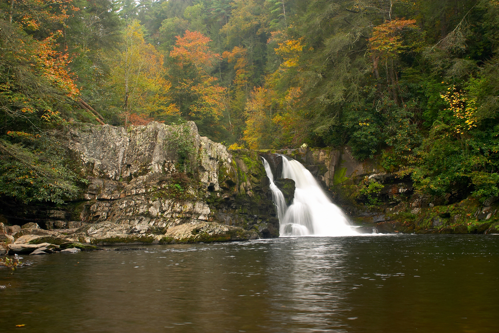
Eighteen smaller streams drain the slopes of the Great Smoky Mountains National Park and empty into Abrams Creek. At the falls, what was the relatively peaceful Abrams Creek is suddenly diverted into a narrow chute along the right side, transforming Abrams to a beautiful twenty-foot plunge over the ledge. During the hot summer months, the natural pool attracts sunbathers and swimmers. During June, the falls are framed by rhododendron and laurel that have grown up the steep bank found at this point on Abrams Creek. The mist created by the plunge of the falls creates a naturally fresh mountain air, and the pool is a wonderful spot to pause, cool off and enjoy some of the very best the park has to offer the visitor.
For those who want to hike further, the remaining two miles of the trail are more isolated and challenging than the section you have just completed. The trail ends at the Abrams Creek Ford, where the hiker can pick up on the Hannah Mountain Trail (which leads left 1.9 miles to the Rabbit Creek Trail at Scott Gap) and Hatcher Mountain Trail (which leads right 2.8 miles to the Cooper Road Trail and the Beard Cane Creek Trail). Otherwise, you can retrace your steps to the Abrams Creek Trail and return to Cades Cove–completing the 5-mile trek to Abrams Falls trail and back. From there, you can continue on the Cades Cove Loop Road to the visitors center where you can refresh yourself and enjoy the remaining historical sites at Cades Cove.
Cades Cove Hiking Trail in the Great Smoky Mountains National Park
If your trek to Abrams Falls is a day-hike, you should take a backpack and carry a few extra items. Include some bottled water, a snack and any other safety items. Never drink the water from any of the national park rivers or streams. Though the streams in the park are invitingly cool and deceptively clear, they contain bacteria that can wreck your trip and a substantial period thereafter. If you are making an overnight trip to LeConte Lodge, you’ll be carrying a backpack, and we assume here that you have included all the necessary items and arranged for the required reservation at the lodge. A backcountry permit is required for overnight stays in the backcountry. Certain campsites are reserved in advance. Smoky Mountain backcountry permits are available online or you can contact the Backcountry Office for more information or assistance with trip planning by calling: 865-436-1297.